The Tide Runneth Over
THE RACE TO PROTECT NANTUCKET’S BARRIER BEACH
Written by Brian Bushard
Photography by Kit Noble
In 1896, the narrow strip called the Haulover breached in a powerful winter storm, severing Coatue and Great Point from the rest of Nantucket with a formidable scar 15 feet deep. Sailors—looking for a faster and safer route to the open ocean—considered it a lucky break. Just over a year after the storm, a catboat called Inaz became the first boat to sail through the new opening, paving the way for larger and larger boats. That breach lasted for 13 years, measuring a quarter-mile long at its widest, according to The Inquirer and Mirror. “That the closing of the Haulover inlet was an unfortunate thing for Nantucket all will admit, and it has had a disastrous effect on the island’s codfishery,” William F. Jones reported in 1909 after the opening naturally sealed itself up.
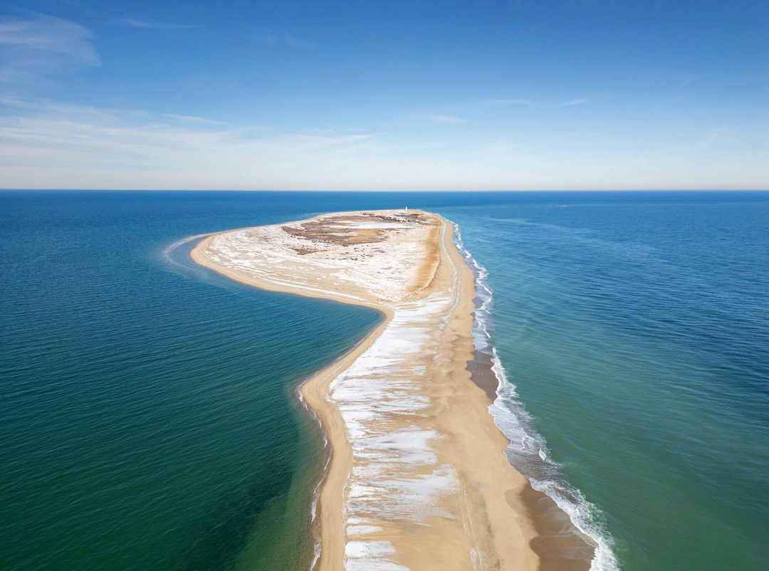
Today, the Haulover is once again at risk of breaching, but this time, as sea-level rise and increasingly stronger storms threaten the island, researchers aren’t sure how long it would take for a new breach to close up. They also aren’t sure if a breach would remain open permanently, drastically changing not only the look of Coatue and Great Point, but leaving the harbor vulnerable to erosion and pounding waves without the protection of a fortified barrier beach. According to Katie Theoharides, president and CEO of The Trustees of Reservations, it’s not a matter of if Great Point will become an island, but when.
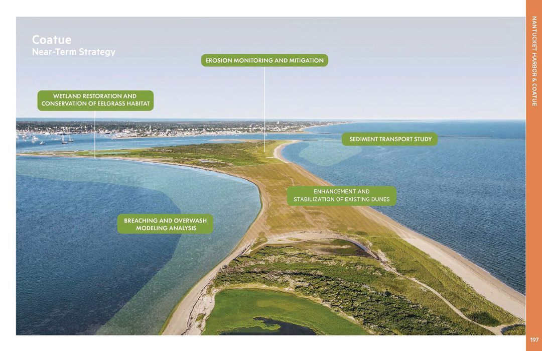
“[By 2100], under moderate sea-level rise projections, we’re looking at 89% of the beach [on Coatue] gone, underwater, and70% of the dunes underwater,” Theoharides said. The Trustees own the Coskata-Coatue Wildlife Refuge extending out to Great Point, while the Nantucket Conservation Foundation owns the majority of Coatue. “This is a beach where thousands of visitors come every summer,” she added. “It’s a touchpoint for Nantucket residents and visitors, and its history is really meaningful. To protect it is our mission.”
Theoharides is one of a number of ecologists growing increasingly concerned about the fate of Coskata and Coatue. As a barrier beach, Coatue keeps the bay scallop population in place, provides refuge for boats in a storm and acts as a natural shield for a 10-mile stretch of the island from Brant Point to Wauwinet. Losing that protection could decimate the bay scallop population, leave harborfront property owners scrambling to protect their homes, and even cut town property tax revenue as harborfront home values drop.
“There is a huge risk,” said Karen Beattie, director of science and stewardship at the Nantucket Conservation Foundation. “If there’s a breach anywhere on Coatue, that is going to change the harbor as we know it today. It would make it a very different place.”
With each storm, Coskata and Coatue become weaker, losing long strips of beach and dunes to the sea. Just this winter, waves from the east swept over the dunes at the narrow isthmus called the Galls—just south of Great Point—effectively making Great Point a temporary island until the storm subsided. Then it happened again, just weeks later and once again at the Galls. While washovers like these have happened before, they’re becoming more common, according to the Trustees. That’s significant for places like Coskata or Coatue, where the highest point sits just six feet above sea level.
“The projections are really scary,” Beattie said. “It does look like Coatue is going to disappear and it may. We don’t know. The bottom line with sea-level rise is that we’re trying to model and predict what’s going to happen as best we can given the science that we have. But at the end of the day, this is uncharted territory.”
By 2050, the National Oceanic and Atmospheric Administration projects the waters around Nantucket to rise by another 2.68 feet and by over 6.6 feet by 2100. Since the installment of the Nantucket Harbor tidal gauge in 1965, the mean sea level in the harbor has already risen by nearly nine inches. That kind of damage could prove disastrous. An estimated 2,373 structures are at risk of coastal flooding and erosion through 2070, coming out to $3.4 billion in damages, according to data from the town’s Coastal Resilience Plan.
RJ Turcotte, ecologist and waterkeeper for the Nantucket Land & Water Council, has already seen the impacts of rising seas. Just this February, the Town Pier suffered substantial damage, three years after a round of repairs were proposed to protect the pier from stronger storm waves. “A breach somewhere like the Haulover could allow for a larger [area] for these waves to build and cause more damage than [the Town Pier] was built for,” Turcotte said.
Town officials and downtown business owners are already contemplating a gauntlet of initiatives to bolster the harborfront. The Steamship Authority is currently seeking grant funding for upgrades to its ferry terminal. Earlier this spring, the Select Board also heard proposals to elevate the harbor bulkhead and potentially raise Easy Street, where just last year, water rose to the height of the road 84 times, according to data from NOAA. That project would cost between $37.5 million and $104.9 million, depending on its scope. Nantucket Coastal Resilience Coordinator Leah Hill believes it’s money well spent. “The risk of doing nothing is way too great,” Hill said. The estimated risk of no action on Easy Street comes out to a whopping $1.2 billion by 2070, not to mention loss of access to the Steamboat Wharf. “We’re a small town with big city problems," Hill said.
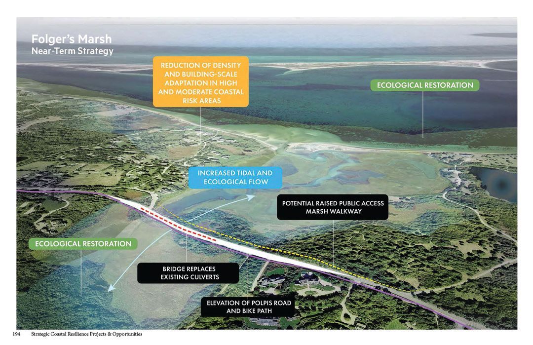
In addition to raising Easy Street, town officials are also considering raising Washington Street, installing an artificial barrier from Brant Point to Monomoy, protecting salt marshes and creating rain gardens to absorb floodwater. Projects like these are not unique to Nantucket. Major cities are now competing for a short supply of state and federal funding for expensive erosion-control projects. In Boston, the proposed “Sapphire Necklace” sea-gate to connect the Boston Harbor Islands came with such a sticker shock when it was proposed in 2017, that the project—like the flooding Seaport—is now dead in the water.
Currently, the Conservation Foundation and the Trustees are looking into projects called living shorelines. They’re intended to work with nature to slow down the rate of erosion by accreting sand along the beach. At Coskata Pond and the Haulover, that looks like vegetation balls and artificial oyster reefs that simultaneously improve water quality and trap sand on the shoreline. The two organizations have also identified two primary risk areas for a breach: the Haulover and Coskata Pond, which sits precariously close to the ocean and empties to the harbor. The organizations have also contracted with GZA Geo Environmental Inc. for a LiDAR topographical survey of low-lying areas that will reveal other risk areas along Coatue. That study is funded by the Great Harbor Yacht Club.
When asked about hard-armoring Coskata or Coatue with options like sea walls, jetties or bulkheads, Theoharides said that kind of approach could do more harm than good in such an undisturbed natural environment like the barrier beach. “Not only do I feel like nature holds the key in allowing our systems to adapt, but without strengthening nature and building its resilience, people won’t be able to experience the natural world the way they do now,” she said. “Hard-armoring would take away all of the unique geomorphology and habitat [of Coskata and Coatue]. What is unique about that environment iscreated by the lack of human intervention.”
While researchers recognize that Coskata and Coatue will almost certainly look very different by the end of the century, there isa consensus that something needs to be done to protect the barrier beach. If nothing is done, the consequences are simply too great, not just for Coskata and Coatue, but for the entirety of the island. “This is not just a beach ecosystem, it really creates the island as we know it today,” Theoharides added. “The more time we can buy with these resiliency measures, the more likely we are to have even more solutions to work with.”
Correction: A previous version of this story incorrectly stated the Trustees owns the Haulover, however that section of Coskata is owned by the Nantucket Conservation Foundation.
Latest Stories